Check the snow report page for all of the resort slope conditions at a glance. See: https://www.skisoutheast.com/skireports.php.
President’s Day Weekend is upon us! It’s hard to believe that it’s already here, but it is. This is always a busy, busy weekend at the ski areas and I’m sure this one will be no different. It’s pretty much the last MAJOR weekend for business at the resorts. Once the calendar turns to March, people who don’t live in the mountains completely forget that there is still snow on the slopes.
With the lack of snow and really cold temps this winter, it’s undoubtedly been a down year in terms of business at the resorts. I’m sure the people running the ski areas are crossing their fingers and hoping for some huge numbers this weekend. The recent cold weather and snow has definitely improved morale in the ski and snowboard community. I’d have to say that in terms of base depths, coverage, and the amount of terrain open, we are seeing some of the best conditions of the season right now. Hopefully others realize this too!
Mike was telling me that he was talking to a few owners and managers of rental shops around here and that several of them mentioned how they were basically out of rentals for the weekend already. That is a great sign! Hopefully the cameras will be showing massive amounts of people throughout the 3 day weekend.
Things are looking pretty good this morning on those cams. The underdeveloped snow yesterday doesn’t appear to have put a dent in conditions too much. Only a few places are reporting a drop in base depth though, which is kind of annoying. In general though, the start of the holiday weekend looks really nice as we should see sunshine prevail in the next few hours.
It also looks like we’re going to be treated to some winter weather this weekend. A Gulf low is going to be moving up across the Southeast over the weekend, bringing snow along with it. This is a typical setup that we see here in the region, and usually this means a huge dump. Right now, it looks like the resorts in West Virginia and Virginia are going to get a pretty good dose of snow on Sunday. Yes, I said the Virginia resorts! Those guys have gotten the shaft the past two seasons when it comes to snow, but it looks like they are going to see a decent helping of the white stuff this weekend. Finally!
Here in North Carolina, we too will see snow but it won’t be nearly as much and it will begin a little later. Honestly, I’m a little worried about underdeveloped snow overnight on Saturday. This system has a ton of moisture with it and precip amounts will add up quickly. It looks like a changeover to snow will happen sometime around midday on Sunday.
None of the major forecasting outlets (NWS, The Weather Channel, Accuweather) have come out and given a quantitative snowfall prediction yet. This is because if there is any change in the path of the system, then that could result in a pretty substantial change in terms of snowfall totals and location. I’m looking at the latest model runs right now and in general it looks like 6-12” is possible for West Virginia and Virginia. The snow is going to be WET and HEAVY, so it’s going to make driving pretty treacherous. Be careful if you are on the roads! Check out a few of the images below which show some snowfall predictions. 
<<< Here is where the Weather Channel is saying the heaviest of snow is going to be. As you can see, the West Virginia and Virginia resorts are going to benefit most from this storm.

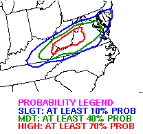
Here is a map from the HPC showing the probability of seeing at least 4 inches of snow. Once again, you can see that West Virginia and Virginia are right in the middle of the highest probability. >>>

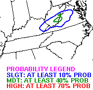
<<< The probability of seeing at least 8 inches is definitely lower, but it’s still there.
So yeah, this weekend is going to be interesting. Sunday looks to be pretty awesome for the West Virginia and Virginia ski areas. It’s a little more iffy here in North Carolina. However, President’s Day is looking fantastic for everyone as sunshine returns. Fresh snow and bluebird skies should make for a perfect ending to the holiday weekend.
With the possibility of a significant snowstorm in West Virginia this weekend, I figured this is a good time to mention the 2012 Ski Southeast Summit at Snowshoe Mountain. The event is only 2 weeks away now! This winter weather over the weekend is only going to improve the conditions up there and they already have the best in the region. With 57 trails open, they are by far leading the way in terms of open terrain. 
If you are a member of the messageboard, you will receive 25% off lodging for the weekend by using the discount code “SNOW” when you make reservations over the phone. You will also receive FREE LIFT TICKETS for that Sunday. Discounted lodging and free skiing at the best resort in the region. Yes please!
That weekend is going to be filled with all kind of events as Mountain Madness will be going on. Live music, volleyball, snowboard comps, and a host of other activities are going to make for a pretty awesome weekend. I’m getting pumped just thinking about it.
Head over to the messageboard and make sure you register ASAP! You can view all the info HERE. I’ll be making an official page today, so I’ll make sure to post that up on the front page later and it will have all the info and other details.
Mike has you guys covered for the weekend, I’ll be back Monday. Enjoy the snow people!
Email me your comments, thoughts, photos, vids or anything else you like at [email protected]
www.HighCountryWeather.com
www.HighCountryWebCams.com

